Published April 16, 2021. Updated January 27, 2024. Open access. | Purchase book ❯ |
Cadle’s Whorltail-Iguana (Stenocercus cadlei)
Reptiles of Ecuador | Sauria | Tropiduridae | Stenocercus cadlei
English common name: Cadle’s Whorltail-Iguana.
Spanish common name: Guagsa de Cadle.
Recognition: ♂♂ 21.3 cmMaximum distance from the snout to the tip of the tail. Snout–vent length=8.5 cm. ♀♀ 18.4 cmMaximum distance from the snout to the tip of the tail. Snout–vent length=7.4 cm..1 The Cadle’s Whorltail-Iguana (Stenocercus cadlei) differs from other lizards in its area of distribution (species in the genera Pholidobolus and Riama) by having keel-shaped dorsal scales with pointed ends.2 Stenocercus cadlei occurs north of the distribution of S. festae and south of S. guentheri, two similar lizard species that may be identified based on ventral coloration.1 Males of these two Stenocercus have a distinct, transverse black band on ventral surface of neck (band absent in S. cadlei) and the females usually have a uniformly-colored belly (bright yellow pectoral patch with a dark reticulation in S. cadlei).1 Additionally, S. festae has a black ante-humeral patch in adult males and distinctly keeled ventral scales in juveniles (patch absent in males and weakly keeled ventral scales in juveniles in S. cadlei).1 Males of S. cadlei differ from females by being larger and having a yellowish-green back (yellowish-brown in females; Fig. 1).1
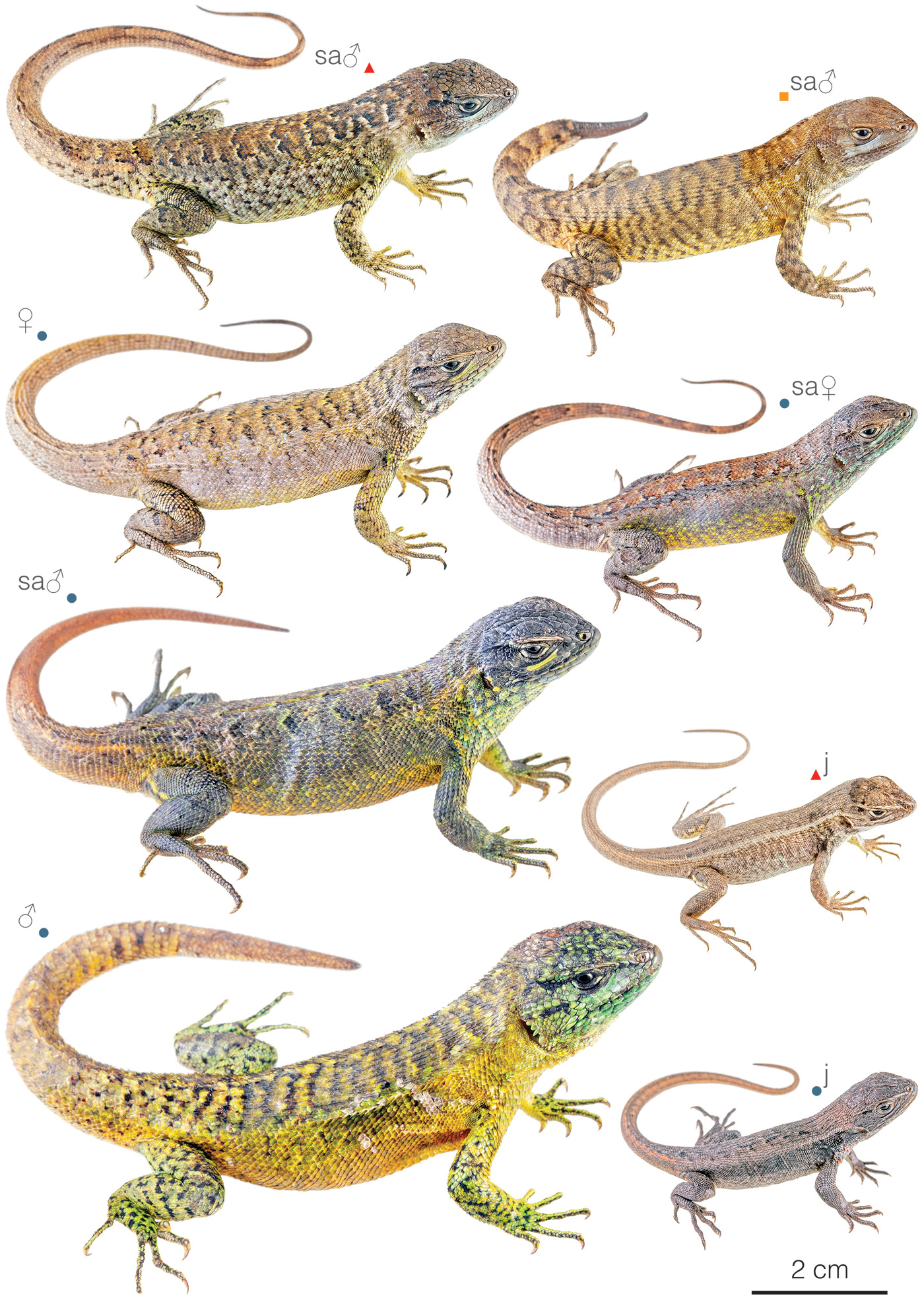
Figure 1: Individuals of Stenocercus cadlei from Ecuador: San Andrés, Tungurahua province (); Tixán, Chimborazo province (); Yaupi, Tungurahua province (). sa=subadult, j=juvenile.
Natural history: Stenocercus cadlei is a diurnal lizard that inhabits high evergreen montane forests, dry to humid highland shrublands, and páramos.3 This species also occurs in human-modified habitats, such as in grasslands, crops, and along roads.1,4–6 Cadle’s Whorltail-Iguanas are usually only seen active between 8:30 am and 2:00 pm during sunny days, basking or foraging at ground level among shrubs or on logs and rock walls.6 Apparently, these lizards prefer ambient temperatures below 29.8°C.1 When dormant, they can be found under rocks, logs, in holes in the ground, or at the base of tall grass tussocks.1,6 Individuals are capable of shedding the tail as an escape mechanism.1 Gravid females contain two eggs.1 Neonates have been found in different months, suggesting that S. cadlei has more than one reproductive season per year.1
By purchasing the hardcover or PDF of the Reptiles of Ecuador, you help keep this website 100% free.
Conservation: Vulnerable Considered to be facing a high risk of extinction in the mid-term future..7 Stenocercus cadlei is included in this category instead of Least Concern8 because although it is a common species that tolerates a moderate degree of habitat disturbance,8 it meets IUCN Red List criteria9 to be listed in the VU category: the species’ extent of occurrence is estimated to be less than 10,000 km2, its habitat is severely fragmented, and there is continuing decline in the extent and quality of the ecosystems where it occurs. Although S. cadlei is found in several protected areas (including Chimborazo Reserve, Llanganates National Park, and Sangay National Park),8 87% of the localities where the species occurs (see Appendix 1) are in heavily human-modified areas.1 Based on maps of Ecuador’s vegetation cover published in 2012,10 no more than ~26% of the potential distribution of the species still holds native vegetation.
Distribution: Stenocercus cadlei is endemic to an area of approximately 6,978 km2 in the semi-xeric inter-Andean valleys and páramos of central Ecuador (Fig. 2).
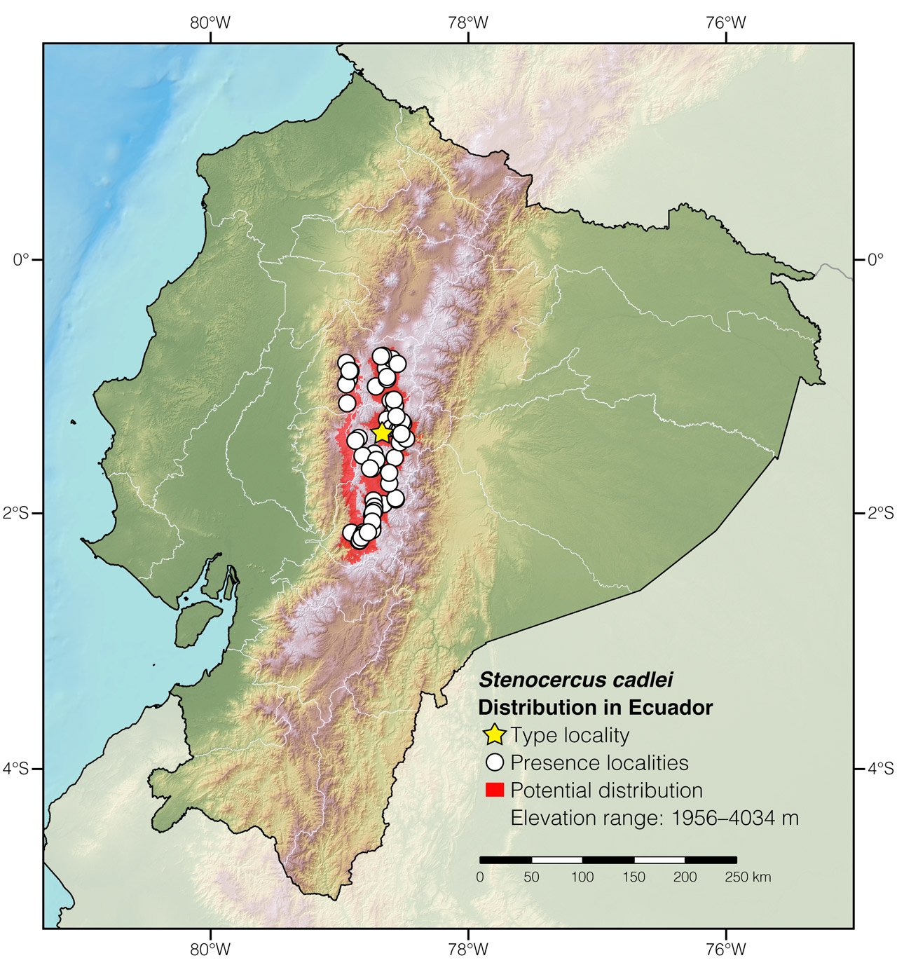
Figure 2: Distribution of Stenocercus cadlei in Ecuador. The star corresponds to the type locality: Santa Lucía, Tungurahua province. See Appendix 1 for a complete list of the presence localities included in the map.
Etymology: The generic name Stenocercus, which comes from the Greek words stenos (=narrow) and kerkos (=tail), refers to the laterally-compressed tail in some members of this genus, which contrasts with the dorsally flattened tail of other Tropiduridae.11 The specific name cadlei honors U.S. herpetologist John E. Cadle, who has made important contributions to the systematics of Stenocercus lizards.1
Where to observe: Cadle’s Whorltail-Iguanas can be seen with almost complete certainty during strongly sunny days in protected areas like Chimborazo Reserve and Laguna de Quilotoa. The best time to look for lizards of this species is during the first hours after sunrise, when the lizards are active and approachable.
Authors: Amanda QuezadaaAffiliation: Tropical Herping (TH), Quito, Ecuador.,bAffiliation: Laboratorio de Herpetología, Universidad del Azuay, Cuenca, Ecuador. and Alejandro ArteagacAffiliation: Fundación Khamai, Reserva Arlequín, Ecoruta Paseo del Quinde km 56, Santa Rosa de Mindo, Pichincha 171202, Ecuador.
Photographers: Jose VieiraaAffiliation: Tropical Herping (TH), Quito, Ecuador.,dAffiliation: ExSitu, Quito, Ecuador. and Alejandro ArteagacAffiliation: Fundación Khamai, Reserva Arlequín, Ecoruta Paseo del Quinde km 56, Santa Rosa de Mindo, Pichincha 171202, Ecuador.
How to cite? Quezada A, Arteaga A (2024) Cadle’s Whorltail-Iguana (Stenocercus cadlei). In: Arteaga A, Bustamante L, Vieira J (Eds) Reptiles of Ecuador: Life in the middle of the world. Available from: www.reptilesofecuador.com. DOI: 10.47051/SOCG1715
Literature cited:
- Torres-Carvajal O, Mafla-Endara P (2013) A new cryptic species of Stenocercus (Squamata: Iguanidae) from the Andes of Ecuador. Journal of Herpetology 47: 184–190. DOI: 10.1670/11-211
- Peters JA, Donoso-Barros R (1970) Catalogue of the Neotropical Squamata: part II, lizards and amphisbaenians. Bulletin of the United States National Museum, Washington, D.C., 293 pp.
- Torres-Carvajal O, Pazmiño-Otamendi G, Salazar-Valenzuela D (2019) Reptiles of Ecuador: a resource-rich online portal, with dynamic checklists and photographic guides. Amphibian & Reptile Conservation 13: 209–229.
- Dávila M, Cisneros-Heredia DF (2017) Use of human-made buildings by Stenocercus lizards (Iguania, Tropiduridae). Herpetology Notes 10: 517–519.
- Mantilla JC, Castaño J (2015) Distribution extension and ecology notes of endemic lizard Stenocercus bolivarensis Castro & Ayala, 1982 (Squamata: Tropiduridae). Herpetology Notes 8: 575–577.
- Field notes, Reptiles of Ecuador book project.
- Reyes-Puig C (2015) Un método integrativo para evaluar el estado de conservación de las especies y su aplicación a los reptiles del Ecuador. MSc thesis, Pontificia Universidad Católica del Ecuador, 73 pp.
- Cisneros-Heredia DF, Reyes-Puig C, Yánez-Muñoz M, Brito J (2017) Stenocercus cadlei. The IUCN Red List of threatened species. Available from: www.iucnredlist.org. DOI: 10.2305/IUCN.UK.2017-2.RLTS.T50950631A50950634.en
- IUCN (2001) IUCN Red List categories and criteria: Version 3.1. IUCN Species Survival Commission, Gland and Cambridge, 30 pp.
- MAE (2012) Línea base de deforestación del Ecuador continental. Ministerio del Ambiente del Ecuador, Quito, 30 pp.
- Duméril AMC, Bibron G (1837) Erpétologie générale ou Histoire Naturelle complète des Reptiles. Librairie Encyclopédique de Roret, Paris, 571 pp. DOI: 10.5962/bhl.title.45973
Appendix 1: Locality data used to create the distribution map of Stenocercus cadlei in Ecuador (Fig. 2). Asterisk (*) indicates type locality.
| Country | Province | Locality | Source |
| Ecuador | Chimborazo | Above Alausí | Reptiles of Ecuador book database |
| Ecuador | Chimborazo | Alausí | MCZ R-146926; VertNet |
| Ecuador | Chimborazo | Alausí, 10 km NW of | USNM 201221; VertNet |
| Ecuador | Chimborazo | Alausí, 5 km NE of | KU 134431; VertNet |
| Ecuador | Chimborazo | Cebadas | Field notes of Elicio Tapia |
| Ecuador | Chimborazo | Columbe | Torres-Carvajal & Mafla-Endara 2013 |
| Ecuador | Chimborazo | Comunidad Melán | Torres-Carvajal & Mafla-Endara 2013 |
| Ecuador | Chimborazo | Guamote | KU 134484; VertNet |
| Ecuador | Chimborazo | Guamote, 20.1 km S of | KU 141234; VertNet |
| Ecuador | Chimborazo | Guamote, 7 km SW of | KU 164174; VertNet |
| Ecuador | Chimborazo | Guamote, 9.5 km S of | KU 141229; VertNet |
| Ecuador | Chimborazo | Guaranda, 36.8 km NE of | KU 202939; VertNet |
| Ecuador | Chimborazo | Mocha, 10.5 km SSW of | KU 179430; VertNet |
| Ecuador | Chimborazo | Mt. Chimborazo | USNM 103277; VertNet |
| Ecuador | Chimborazo | Palmira, 11.3 km N of | Torres-Carvajal & Mafla-Endara 2013 |
| Ecuador | Chimborazo | Palmira, 2.5 km S of | KU 164173; VertNet |
| Ecuador | Chimborazo | Palmira, 5.2 km S of | KU 141248; VertNet |
| Ecuador | Chimborazo | Penipe | Burneo & Boada 2012 |
| Ecuador | Chimborazo | Pungala, 8.2 km SE of | KU 141256; VertNet |
| Ecuador | Chimborazo | Riobamba, 10 km N of | KU 134496; VertNet |
| Ecuador | Chimborazo | Riobamba, 12.1 km E of | KU 141257; VertNet |
| Ecuador | Chimborazo | Ríobamba, 5 km W of | USNM 201220; VertNet |
| Ecuador | Chimborazo | Riobamba, 6.7 km E of | KU 202941; VertNet |
| Ecuador | Chimborazo | San Juan, 4.1 km E of | KU 141259; VertNet |
| Ecuador | Chimborazo | Surrondings of Tixán | MZUTI 4550; VertNet |
| Ecuador | Chimborazo | Tixán, 0.3 km S of | KU 141236; VertNet |
| Ecuador | Chimborazo | Tixán, 1.1 km S of | KU 141238; VertNet |
| Ecuador | Chimborazo | Tixán, 14.5 km N of | Torres-Carvajal & Mafla-Endara 2013 |
| Ecuador | Chimborazo | Tixán, 2.8 km S of | Torres-Carvajal & Mafla-Endara 2013 |
| Ecuador | Chimborazo | Tixán, 5 km NE of | KU 164171; VertNet |
| Ecuador | Cotopaxi | Angamarca | GP Angamarca 2019 |
| Ecuador | Cotopaxi | Apagua | Torres-Carvajal & Mafla-Endara 2013 |
| Ecuador | Cotopaxi | Caserío Poatug | Torres-Carvajal & Mafla-Endara 2013 |
| Ecuador | Cotopaxi | Chugchilán, 2 km S of | Torres-Carvajal & Mafla-Endara 2013 |
| Ecuador | Cotopaxi | Cotaló | Torres-Carvajal & Mafla-Endara 2013 |
| Ecuador | Cotopaxi | Guaytacama | iNaturalist; photo examined |
| Ecuador | Cotopaxi | La Merced | Chicaiza & Tapia 2016 |
| Ecuador | Cotopaxi | Laguna de Yambo | Torres-Carvajal & Mafla-Endara 2013 |
| Ecuador | Cotopaxi | Laguna Quilotoa | iNaturalist; photo examined |
| Ecuador | Cotopaxi | Latacunga | MCZ R-164907; VertNet |
| Ecuador | Cotopaxi | Latacunga, 1 km W of | KU 127103; VertNet |
| Ecuador | Cotopaxi | Mirador Laguna Quilotoa | Reptiles of Ecuador book database |
| Ecuador | Cotopaxi | Mulaló | Torres-Carvajal & Mafla-Endara 2013 |
| Ecuador | Cotopaxi | Patate | Torres-Carvajal & Mafla-Endara 2013 |
| Ecuador | Cotopaxi | Pujilí, 37.8 km W of | KU 152173; VertNet |
| Ecuador | Cotopaxi | Río Ambato | Torres-Carvajal & Mafla-Endara 2013 |
| Ecuador | Cotopaxi | Río Barrancas | Torres-Carvajal & Mafla-Endara 2013 |
| Ecuador | Cotopaxi | Road Guaranda–Ambato | Torres-Carvajal & Mafla-Endara 2013 |
| Ecuador | Cotopaxi | Road to Píllaro | Torres-Carvajal & Mafla-Endara 2013 |
| Ecuador | Cotopaxi | San Juan de Pasto Calle | Torres-Carvajal & Mafla-Endara 2013 |
| Ecuador | Cotopaxi | Tanicuchi | iNaturalist; photo examined |
| Ecuador | Cotopaxi | Urbina | Torres-Carvajal & Mafla-Endara 2013 |
| Ecuador | Tungurahua | Ambato | MCZ R-8430; VertNet |
| Ecuador | Tungurahua | Ambato, 10 km E of | KU 134523; VertNet |
| Ecuador | Tungurahua | Baños, 17.8 km W of | KU 141209; VertNet |
| Ecuador | Tungurahua | Chambo Grande | KU 146670; VertNet |
| Ecuador | Tungurahua | Entre Aguaján y Ambato | Photo by David Velastegui |
| Ecuador | Tungurahua | Patate, 5.6 km SSE of | KU 141201; VertNet |
| Ecuador | Tungurahua | Río Patate, 3 km S of | USNM 201244; VertNet |
| Ecuador | Tungurahua | San Andrés | This work; Fig. 1 |
| Ecuador | Tungurahua | San Miguelito, 3 km SSW of | KU 132491; VertNet |
| Ecuador | Tungurahua | Santa Lucía* | Torres-Carvajal & Mafla-Endara 2013 |
| Ecuador | Tungurahua | Vinge | KU 141195; VertNet |
| Ecuador | Tungurahua | Yaupi | This work; Fig. 1 |