Published September 11, 2021. Updated November 24, 2023. Open access. Peer-reviewed. | Purchase book ❯ |
Reticulated Sticklizard (Pholidobolus affinis)
Reptiles of Ecuador | Sauria | Gymnophthalmidae | Pholidobolus affinis
English common name: Reticulated Sticklizard.
Spanish common names: Cuilanpalo reticulado, cuilán reticulado.
Recognition: ♂♂ 16.2 cmMaximum distance from the snout to the tip of the tail. Snout–vent length=6.4 cm. ♀♀ 19.3 cmMaximum distance from the snout to the tip of the tail. Snout–vent length=5.8 cm..1,2 Sticklizards differ from other lizards by having short but well-developed limbs, overlapping striated sub-hexagonal dorsal scales, and a brownish dorsal pattern with longitudinal stripes.1,3 The presence of six-sided finely wrinkled dorsal scales distinguishes Pholidobolus from other co-occurring small brownish lizards such as those in the genera Alopoglossus, Anadia, Andinosaura, Macropholidus, and Riama.4 The Reticulated Sticklizard (P. affinis) co-occurs with P. montium in the north and with P. prefrontalis in the south of its distribution. It is easily differentiated from these two species by having three, instead of two, supraocular scales.3 Males of P. affinis differ from females by having an intense yellow to orange-red coloration along the flanks and belly, instead of pale yellow or gray (Fig. 1).1
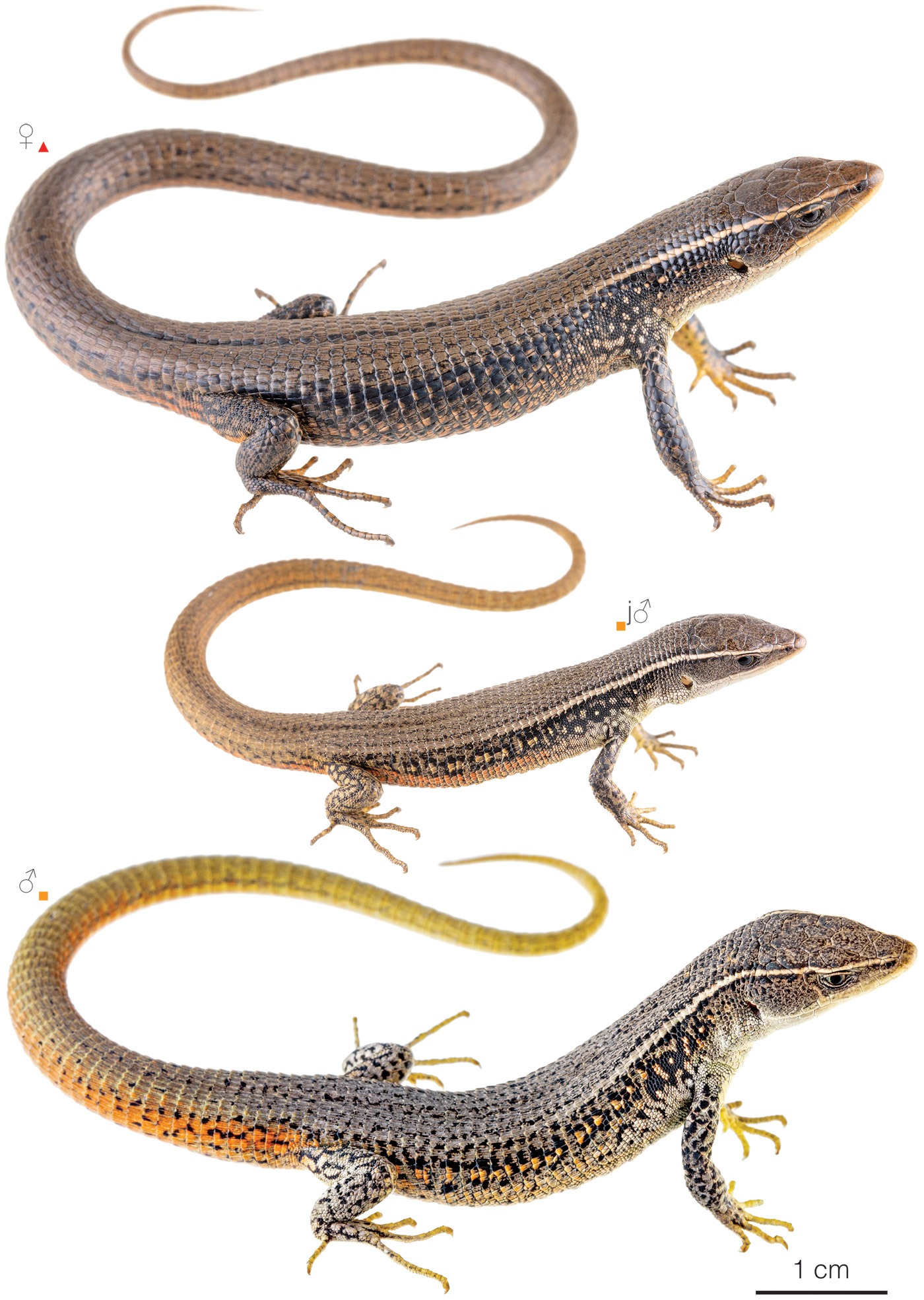
Figure 1: Individuals of Pholidobolus affinis from southern Ecuador: Tixán, Chimborazo province (); Yaupi, Tungurahua province (), Ecuador. j=juvenile.
Natural history: Pholidobolus affinis is a common diurnal and terrestrial lizard that inhabits undisturbed open areas such as páramo and dry to humid high elevation shrubland. It also occupies disturbed areas such as roadsides, crops, pastures, rural gardens, and houses.1,5 Reticulated Sticklizards occur in tufts of grass, stone walls, living agave plant fences, and under rock mounds or piles of trash near human settlements.1–7 These lizards are often seen basking on rocks, agave plants, bromeliads, or wooded platforms during sunny periods.1,5 When living alongside P. montium, both species are tolerant of each other, congregating on stone walls for basking.1 When threatened, individuals take refuge in the vegetation or under stones; when handled, they can bite or readily shed the tail.5 The typical clutch size consists of two eggs.1
By purchasing the hardcover or PDF of the Reptiles of Ecuador, you help keep this website 100% free.
Conservation: Vulnerable Considered to be facing a high risk of extinction in the mid-term future.. Pholidobolus affinis is proposed to be included in this category, instead of Near Threatened,6,8 following IUCN criteria,9 because the species’ extent of occurrence is small (~3,009 km2; Fig. 2), severely fragmented, and continues to decline in extent and quality due to rural-urban expansion. Based on maps of Ecuador’s vegetation cover published in 2012,10 almost all (~92%) of the species’ potential distribution is now devoid of native vegetation. Although it is a common species, P. affinis is found in lower densities than before, probably due to the increasing anthropic activity.1,7 Furthermore, only ~0.6% of the species’ potential distribution is inside protected areas (Llanganates National Park). Habitat destruction is the most important threat to the long-term survival of the species.
Distribution: Pholidobolus affinis is native to an area of approximately 3,009 km2 in the inter-Andean valleys of central Ecuador, in the provinces Chimborazo, Cotopaxi, and Tungurahua (Fig. 2).
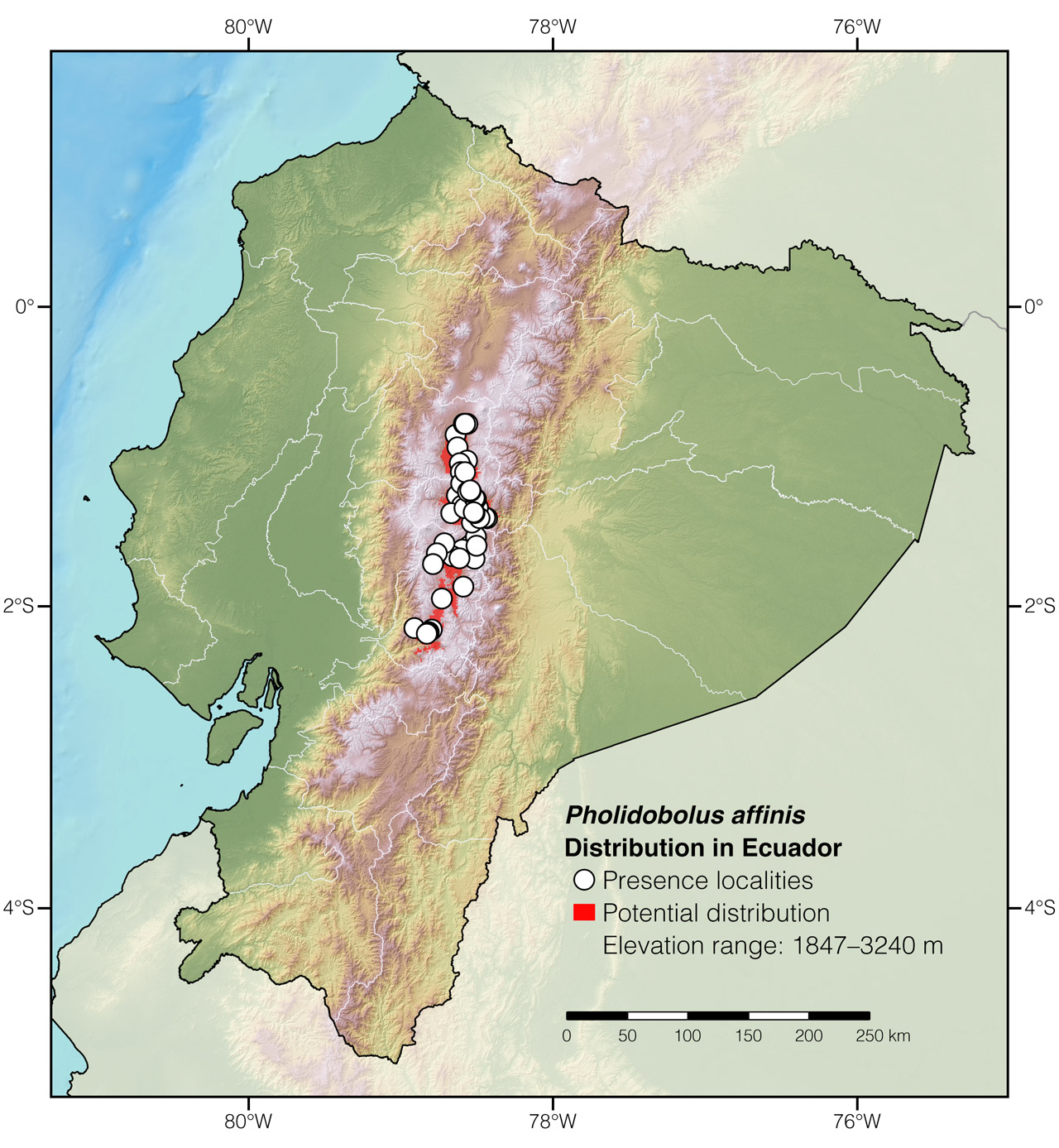
Figure 2: Distribution of Pholidobolus affinis in Ecuador. The type locality is not included as it is uncertain.
Etymology: The generic name Pholidobolus comes from the Greek words pholidos (=scale) and bolos (=lump),11 and probably refers to the imbricated or mounted scales. The specific epithet affinis is a Latin word meaning “similar.”11 It most likely refers to the row of scales immediately posterior to the parietals, which, contrary to other Pholidobolus, are similar in size to the neck scales and can barely be considered occipital scales. This is the only instance the word “similar” is used in the original description of the species.12
Where to observe: Reticulated Sticklizards can easily be observed in areas having remnants of native shrubland vegetation around cities and towns such as Latacunga, Ambato, Pelileo, and Tixán. Lizards of this species can be found by searching under rocks and logs in pastures near remnants of native vegetation or simply by looking along stone walls and living fences during sunny days
Author: Amanda QuezadaaAffiliation: Tropical Herping (TH), Quito, Ecuador.,bAffiliation: Laboratorio de Herpetología, Universidad del Azuay, Cuenca, Ecuador.
Editor: Alejandro ArteagaaAffiliation: Fundación Khamai, Reserva Arlequín, Ecoruta Paseo del Quinde km 56, Santa Rosa de Mindo, Pichincha 171202, Ecuador.
Academic reviewer: Jeffrey D CamperbAffiliation: Department of Biology, Francis Marion University, Florence, USA.
Photographers: Jose VieiracAffiliation: Tropical Herping (TH), Quito, Ecuador.,dAffiliation: ExSitu, Quito, Ecuador. and Alejandro ArteagaaAffiliation: Fundación Khamai, Reserva Arlequín, Ecoruta Paseo del Quinde km 56, Santa Rosa de Mindo, Pichincha 171202, Ecuador.
How to cite? Quezada A (2023) Reticulated Sticklizard (Pholidobolus affinis). In: Arteaga A, Bustamante L, Vieira J (Eds) Reptiles of Ecuador: Life in the middle of the world. Available from: www.reptilesofecuador.com. DOI: 10.47051/RHRA8839
Literature cited:
- Montanucci RR (1973) Systematics and evolution of the Andean Lizard genus Pholidobolus (Sauria: Teiidae). Miscellaneous Publications of the Museum of Natural History, University of Kansas 59: 1–52.
- Boulenger GA (1885) Catalogue of the lizards in the British Museum. Taylor & Francis, London, 497 pp.
- Torres-Carvajal O, Venegas P, Lobos SE, Mafla-Endara P, Sales Nunes PM (2014) A new species of Pholidobolus (Squamata: Gymnophthalmidae) from the Andes of southern Ecuador. Amphibian & Reptile Conservation 8: 76–88.
- Peters JA, Donoso-Barros R (1970) Catalogue of the Neotropical Squamata: part II, lizards and amphisbaenians. Bulletin of the United States National Museum, Washington, D.C., 293 pp.
- Field notes, Reptiles of Ecuador book project.
- Cisneros-Heredia DF, Muñoz G, Brito J, Valencia J (2017) Pholidobolus affinis. The IUCN Red List of threatened species. Available from: www.iucnredlist.org. DOI: 10.2305/IUCN.UK.2017-2.RLTS.T48283076A48283161.en
- Hillis DM, Simmons JE (1986) Dynamic change of a zone of parapatry between two species of Pholidobolus (Sauria: Gymnophthalmidae). Journal of Herpetology 20: 85–87. DOI: 10.2307/1564130
- Carrillo E, Aldás A, Altamirano M, Ayala F, Cisneros-Heredia DF, Endara A, Márquez C, Morales M, Nogales F, Salvador P, Torres ML, Valencia J, Villamarín F, Yánez-Muñoz M, Zárate P (2005) Lista roja de los reptiles del Ecuador. Fundación Novum Millenium, Quito, 46 pp.
- IUCN (2001) IUCN Red List categories and criteria: Version 3.1. IUCN Species Survival Commission, Gland and Cambridge, 30 pp.
- MAE (2012) Línea base de deforestación del Ecuador continental. Ministerio del Ambiente del Ecuador, Quito, 30 pp.
- Brown RW (1956) Composition of scientific words. Smithsonian Books, Washington D.C., 882 pp.
- Peters WCH (1863) Über einige neue Arten der Saurier-Gattung Anolis. Monatsberichte der Königlichen Preussische Akademie des Wissenschaften zu Berlin 1863: 135–149.
Appendix 1: Locality data used to create the distribution map of Pholidobolus affinis in Ecuador (Fig. 2).
| Country | Province | Locality | Source |
| Ecuador | Chimborazo | Alausí, 10 km NW of | USNM 521388; VertNet |
| Ecuador | Chimborazo | Alausí, near Tixán, 10 km NE of | Montanucci 1973 |
| Ecuador | Chimborazo | Colta | Torres-Carvajal et al. 2014 |
| Ecuador | Chimborazo | Cubijies, 8.4 km N of | Montanucci 1973 |
| Ecuador | Chimborazo | Guamote | Montanucci 1973 |
| Ecuador | Chimborazo | Guano, 4 km E, 1 km S of | KU 179434; VertNet |
| Ecuador | Chimborazo | Licto, 8 km SE of | Montanucci 1973 |
| Ecuador | Chimborazo | Puela, 2.6 km S of | KU 196319; VertNet |
| Ecuador | Chimborazo | Riobamba | iNaturalist; photo examined |
| Ecuador | Chimborazo | Riobamba, 10 km N of | Montanucci 1973 |
| Ecuador | Chimborazo | Riobamba, 15 km E of | Montanucci 1973 |
| Ecuador | Chimborazo | Riobamba, 6.7 km E of | KU 196317; VertNet |
| Ecuador | Chimborazo | San Juan, 4.1 km E of | Montanucci 1973 |
| Ecuador | Chimborazo | Sicalpa | Torres-Carvajal et al. 2014 |
| Ecuador | Chimborazo | Tixán, 0.3 km S of | Montanucci 1973 |
| Ecuador | Chimborazo | Tixán, 1.5 km SW of | MZUTI 4509; examined |
| Ecuador | Chimborazo | Tixán, 2.9 km S of | Montanucci 1973 |
| Ecuador | Cotopaxi | Guaytacama, 3.3 km SE of | iNaturalist; photo examined |
| Ecuador | Cotopaxi | Latacunga | iNaturalist; photo examined |
| Ecuador | Cotopaxi | Latacunga, 6 km S and 7 km E of | Montanucci 1973 |
| Ecuador | Cotopaxi | Mulaló, 0.3 km N of | Montanucci 1973 |
| Ecuador | Cotopaxi | Mulaló, 1 km NE of | Montanucci 1973 |
| Ecuador | Cotopaxi | Mulaló, 2.9 km E of | Montanucci 1973 |
| Ecuador | Cotopaxi | Salcedo, 3.3 km S of | KU 196315; VertNet |
| Ecuador | Cotopaxi | Salcedo, Río Cutuchi | Torres-Carvajal and Mafla-Endara 2013 |
| Ecuador | Tungurahua | Ambato | Montanucci 1973 |
| Ecuador | Tungurahua | Ambato, 10 km E of | Montanucci 1973 |
| Ecuador | Tungurahua | Aya Samana | Torres-Carvajal et al. 2014 |
| Ecuador | Tungurahua | Baños de Ambato | Montanucci 1973 |
| Ecuador | Tungurahua | Baños–Patate | Reptiles of Ecuador book database |
| Ecuador | Tungurahua | Baños, Río Bascún | Photo by Enrique Mariño |
| Ecuador | Tungurahua | Cerro Llanganate | Montanucci 1973 |
| Ecuador | Tungurahua | Chambo Grande, 17.8 km W of | Montanucci 1973 |
| Ecuador | Tungurahua | Chamisa, on road to Guadalupe | Torres-Carvajal et al. 2014 |
| Ecuador | Tungurahua | Cotaló, on road to Mucubí | Torres-Carvajal et al. 2014 |
| Ecuador | Tungurahua | Laguna de Yambo | iNaturalist; photo examined |
| Ecuador | Tungurahua | Mocha, 6 km N of | Torres-Carvajal et al. 2014 |
| Ecuador | Tungurahua | Nuevo Amancer | MZUTI 4721; examined |
| Ecuador | Tungurahua | Patate | Torres-Carvajal et al. 2014 |
| Ecuador | Tungurahua | Patate, 13 km SSE of | Montanucci 1973 |
| Ecuador | Tungurahua | Patate, 8.9 km SSE of | Montanucci 1973 |
| Ecuador | Tungurahua | Pelileo, 1.1 km SW of | KU 196320; VertNet |
| Ecuador | Tungurahua | Pelileo, 2 km W of | UIMNH 95172; VertNet |
| Ecuador | Tungurahua | Poatug, sector Terremoto | Torres-Carvajal et al. 2014 |
| Ecuador | Tungurahua | Rio Patate, 2–3 km S of | Montanucci 1973 |
| Ecuador | Tungurahua | San Andrés | Reptiles of Ecuador book database |
| Ecuador | Tungurahua | San Miguelito, 3 km SSW of | Montanucci 1973 |
| Ecuador | Tungurahua | San Miguelito, on road to Píllaro | Torres-Carvajal et al. 2014 |
| Ecuador | Tungurahua | San Miguelito, on road to Terán | Torres-Carvajal et al. 2014 |
| Ecuador | Tungurahua | Yaupi | This work; Fig. 1 |